Showing posts with label treaking. Show all posts
Showing posts with label treaking. Show all posts
Wednesday, June 03, 2015


Tuesday, April 26, 2011


Friday, April 15, 2011
Travel and Adventure: Sajjangad ...... 1

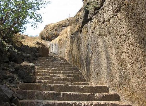
 Shambhu Mahadev is the sub range of Sahyadri starting from Pratapgad to eastern side. This range is divided into three parts and Sajjangad is situated on one of these sub ranges. One should touch the soil here sanctified by the feet of Samrath Ramdas Swami. Poet Anant has aptly described the place the sacred one, blessed by the existence of Lord Hanuman and residence of Saint Ramdas Swami. The fort stands 10 km away to the south- west of the Satara city in the ravine of the Urmodee or Urvashee River.
Location: West of Satara
Distance from major cities:
Mumbai - 290 km
Pune - 130 km
Satara - 20 km
Villages at Foothills: Parali, Gajwadi
Altitude: 4320 ft (1317 m)

 In ancient time, saint Ashwalayan resided on this hill, due to which the fort is also known as Ashwalayan gad. It also changed into Ashwalgad. The fort was created by king Bhoj from Shilahar dine sty in 11th century. The village at the base of the fort is as Parali so the fort was also called as, the fort of Parali. The mention of this fort is found in the region of the 4th Bahamani king Mahommad Shah (1358 to 1375). Later, it went in the hands of Adilshah who grabbed a portion of Bahamani state. The mention of Phajal khan is found in 1632 as the in charge of the fort. On 2nd April 1673, this fort was conquered by Shivaji Maharaj from Adilshah. Saint Samarth Ramdas permanently resided on this fort as per the request of Shivaji Maharaj. And the fort was named as Sajjangad. Then, after coronation, Shivaji Maharaj came for blessings of Samarth on 3-11-1678, Shivaji Maharaj sent Sambhaji to Sajjangad. However, Sambhaji ran away from Sajjangad on 3rd December 1678 and joined Dilerkhan. After unfortunate death of Shivaji Maharaj on 18 January 1682, the idol of Shriram was on the fort. Ramdas Swami also passed away on 22-1-1682. Though Samarth transferred all the rights regarding the fort to Divakar Gosavi, the administration was allotted to Bhanji and Ramji Gosavi. However conflicts arose between them. When Sambhaji Maharaj heard about it, he wrote to Jijoji Katkar, the Killedar of Sajjangad. The letter intended to settle the dispute and to follow the orders of the respected elder people. Later on 21 April 1700, the fort was captured by Moghals and named by then as`Nauras-Satara,. In 1709 Marathas captured the fort. However in 1818 the fort fell in the hands of British.
Monday, March 07, 2011
Travel and Adventure: Mandangad ..... Part 2


 Ambewadi village Route (Grade: Tough): 5 hrs - The first stop is either Igatpuri or Kasara. There is Igatpuri / Kasara - Ghoti - Pimpalnermor - Ambewadi S.T. service. There are also ST services from Ghoti to Ambewadi. The distance between Ambewadi and Ghoti is around 32 Kms. The first S.T. Bus to Ambewadi from Ghoti leaves at 6.00 a.m. The three forts of Alang, Kulang and Madan are visible right from Ambewadi village. There is a route to reach the intersecting ridge between Alang and Madan. This route is quite steep and exhausting. It takes approximately 3 hours to reach the ridge. Once you reach the ridge you see the fort of Alang to the left and Madan to the right. Turning to the right we reach the steps carved out of the rock face going to the rock face of Madangad. From the end of the steps, one has to do a steep climb of about 40 feet to reach the upper route of Madangad. One has to use rock-climbing techniques to climb this patch. A bolt has been fixed in the middle of the rock patch to help climbers make an easier ascent. After the climb, the route turns left and goes up to take us right near the water tank on top of the fort.
Ghatghar via Ghoti-Bhandardara - 4 hrs
The second route to Madan is from Ghatghar. This route is via Ghoti - Bhandardara - Ghatghar. It takes 4 hours to reach the ridge between Alang and Madan from Ghatghar.

Friday, March 04, 2011
Travel and Adventure: Mandangad ..... Part 1

 Madangad is considered to be one of the most difficult forts to climb among all the forts in the Sahyadris. The fort is quite old and also impregnable. The most appropriate time to trek this region is between December and January.
Location: North West of Nasik
Villages at Foothills: Ambewadi
Altitude: 4841' (1476 m)

The area of the fort is quite small as compared to Alang and Kulang, its adjoining forts. There are only two water tanks on top of the fort in which water is available only till February. There is a cave, which can accommodate around 15-20 trekkers at a time. The area visible from the top of the fort is quite scenic. One can see Alang, Kulang, Chota Kulang, Ratangad, Ajyagad, Katrabai, Dangya Pinnacle, Harihar and Tryambakeshwar. It takes only half an hour to see the complete fort.
Nasik Road is the nearest rail head. From Nasik one needs to reach Satana or Taharabad. Only 2 buses ply to the foothills of the fort, and hence one needs to plan the trek well.


Sunday, February 13, 2011
Visapur Fort ....... Part 2

The main characteristic of this fort is the strong fortification built on a large plateau, to make it one of the strongest forts. A large plateau of this size is found on many less forts. It is difficult to fire cannons on the fort due to its position. We can see the injuries of destruction caused by Mughals and British on Bhaje caves, but this has not affected Visapur much. The long stretched ramparts fascinate us. On this same plateau we can see a huge stone wheel. It was used for grinding the mixture of lime, jaggery & lead. This mixture was used as cementing material for building purposes. The wheel was driven by bulls, and is the big one of its kind. Other things that add to the uniqueness of the fort are constructions like the bastion on the western side of the fort. This bastion, unlike others is completely within the main ramparts. Such a construction is rarely seen on other forts. The other remnants include old residential places. There is a fountain on the northwestern side.

Trek Routes:
- From Malavali (Grade: Easy) -
First route is quite confusing and we may need guide to reach the fort from the village itself. When the Bhaje caves come to our sight we leave stairways & go towards right. For walking upto15 to 20 min we come across small huts. From here the way through jungle takes us to the broken stairs. When we start climbing these stairs there is a small temple & two big caves which can accommodate about 40 people. These stairs straightway take us to the fort of Visapur.

- Gaikhind route (Grade: Easy) -
The second route is from just before Lohagadwadi. From here after reaching Gaimukh Khind we go towards left, which takes us to Visapur fort. This way also takes us through jungle and is much better. This must have been the main entrance, as it is in front of the main door to Lohgad. Moreover well-cut steps are seen here.

- Patan route (Grade: Easy) -
The third route is from the base village named Paatangaon on the western side. Here the way is less confusing, and this joins the way on the first route. This was the way towards the trade route, and some cisterns are on this way. Also two caves and carved idol of Lord Hanuman is seen here. This way is very pleasant.

Sunday, January 30, 2011
Visapur Fort ....... Part 1

The forts of Lohgad and Visapur have played an important role in guarding the ancient trade routes and being the savior of Bhaje and Bedse caves. Among them, Lohgad is related to many significant historical events. Much of it is known. Unlike that, much less is known about Visapur. In spite of being a very big fort, protected by a highly impregnable fortification and presence of a large plateau, less is written about it, or much less records could have added to information about it.

Location: Lonavala
Distance from major cities:
 Mumbai - 120 km
Pune - 90 km
Lonavala - 10 km
Villages at Foothills: Patan, Bhaje, Lohagadwadi
Lohgad and Visapur lay in Nane Maval. This region came under Nizamshahi after dissolution of Bahmani rule. It went into the hands of Mughals in the treaty of Mahuli, between Shahajiraje and Mughals. Seeing that the Mughals were not able to keep a control over the region, Shivaji Maharaj captured almost all the forts here till 1660. However, he lost the fort again to Mughals in the treaty of Purandar in 1665. However Aurangzeb broke the treaty. In 1682, Shahbuddin, a Mughal Sardar invaded the region, and killed 60 Marathas in an anguish. However Marathas escaped to Visapur. They were chased, but moved in time to the village of Kusapur. On March 4, 1818 Colonel Prother captured Visapur, and the next day Lohgad fell into his hands. The mountain of Visapur is significant, as Bhaje caves have been carved out in the same mountain. The destruction caused by Mughals and English is clearly evident from the injuries on the Bhaje caves. These beautiful caves could have been bombarded by cannon balls, because much of their part has been broken.


Subscribe to:
Posts (Atom)